Sunday, 29 May 2011

Saltram House


We have been to Saltram Park and gardens many times this year, but we have never been inside the house.  The weather today was grey and overcast so we decided we would start the afternoon by touring the house.  It was full of pictures, furniture and household objects and well worth looking around. There was a special exhibition in the kitchen and this was particularly interesting.


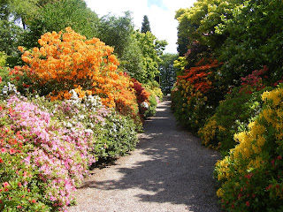
By the time we came outside it was a bit brighter and we walked around the gardens and again we surprised by the many different flowers that were out that brought colour to the gardens.

Aliums and irises
Foxgloves and rhododendrons
Wild orchid among buttercups

A Cranesbill contrasts with a  pink flowering shrub that I did not recognise.


Friday, 27 May 2011

Truro to Tresillian

The train to Truro was crowded and ran late, but it was still preferrable to driving.   We had never been to Truro before so started by exploring the town, with its mixture of small shops and national chains.  The station is at the top of the town and we made our way down to Lemon Quay then crossed the roads by subway to Malpas Road.  Before long we were walking along the riverside.  This walk took us all the way to Malpas, a small village at the junction of the river and creek.

We continued walking as far as we could along the road then followed the footpath into woods.  When we came to 2 bridges we ignored the sign to St Clements that went up a hill through a field and instead turned left through the woods.  This path followed the creek through woods and was a long way around to St Clement but was a waterside walk.  Taking this path we missed the main part of the village and just saw the houses on the waterside, one of which had a lovely garden.

From St Clement we walked along a carriage drive which was flat and easy walking along the creek and took us to just outside Tresillian.  When we reached the road we walked along until we came to a bus stop and then caught the bus back to Truro and from there the train to Plymouth.

Tuesday, 24 May 2011

Totnes to Ashprington

We caught the train to Totnes and walked down from the station to the River Dart, where we started to follow the Dart Valley Trail.  However, after a short while we could not see where to go.  We walked through an industrial estate before realising we had missed the path.  When we retraced our steps we saw  the cycle path which we intended to return on, so decided to take this path and come back on the footpath.

The cycle path was a good path to walk on and no cyclist used it while we were walking along it.  It climbed slowly up a hill while following the direction of the river, which we could see occasionally below.  Eventually we joined up with the footpath and continued on that way.  Above Ashprington we turned left to divert to Sharpham Vineyard.  It was a steep hill down and as we did not want to pay £4.75 to look around the vineyard it was a bit of a waste of time.  However, by taking this road down we got wonderful views back to Totnes along the river.


We climbed back up the hill and continued on to Ashprington.  Initially there was a footpath at the side of the road and then through a playing field but then we had to walk down the narow road.  Ashprington was a pretty village, but we did not stop but walked down the hill to Bow Bridge, where there was a pub with tables outside at the side of the creek.  Very pretty and a welcome rest.

On the way back we kept to the Dart Valley Trail, which was well marked and a flatter route than the cycle route.  Once back in Totnes we saw how we had missed our way at the beginning - we should have walked through the higher part of the industrial estate, not the lower part next to the river!

Saturday, 21 May 2011

Teignmouth to Dawlish Warren

We took the train to Teignmouth and it was only a stone's throw from the station to the sea front.  The South West Coastal path runs along the sea wall.  It was nearly high tide and the waves were hitting the sea wall at times but we were able to walk along in the dry.  On the other side of the path was the railway line, and at times trains rushed past us.

Looking back to Teignmouth, with train coming along

View in the opposite direction with another train

At the end of Teignmouth beach we had to turn inland and go along roads and a footpath between hedges before coming out above Dawlish and wind our way down to the town.

View over Dawlish

Heading towards Dawlish

Looking back around the coast which we had skirted by going inland

We wandered through Dawlish town and found an excellent bakery, Gays Creamery where we bought pasty's and ate them by the river in a very pleasant park.

Dawlish is famous for their black swans

From Dawlish we continued to walk along the path above the beach to Dawlish Warren.  We continued on from the South West Path into the nature reserve at the end of Dawlish Warren, but at the visitor centre turned back and made our way back to Dawlish Warren railway station from where we caught the train back to Plymouth.

Tuesday, 17 May 2011

Shipley Bridge

The wild rhododendrons were flowering so we thought it would be a good time to walk along the river at Shipley Bridge.  Some were out, but we were a couple of weeks too early.  We had not taken into account the fact Shipley Bridge is quite high on the moors and must be colder than in the valley.  The River Avon was not  very full so also not as attractive as it could be.


Monday, 16 May 2011

Bantham to Hope Cove

We parked the car at South Milton Sands and first walked to Bantham.  although it was 3 miles it was realatively easy walking, undulating up and down and only steep as we made our way down to Bantham itself.
The tide was out so the coastline was not as attractive as at high water, but it was nevertheless a pleasant walk.

Burgh Island at low tide

After lunch on Bantham beach we walked back to South Milton Sands and then, after a cup of tea, on to Hope Cove.  It was a very windy day and as we walked past South Milton Sands there were windsurfers and kite surfers in the sea.

Milton Sands and Thurleston Rock

Saturday, 14 May 2011

Coleton Fishacre to Scabbacombe Head

First we walked through Coleton Fishacre's gardens, which were looking spectacular.


At the bottom of the garden we went through the gate onto the South West Coast Path.  We had intended to walk towards Kingswear, but someone watching wildlife by the viewpoint recommended we went in the opposite direction as it was an easier walk.

The views from the path were lovely.


At one point we came to obstacles on the path, a group of horses that were right in front of the gate we needed to go through.  Fortunately as we slowly approached them  they decided to move away.


When we reached Scabbacombe Head we could see down to Scabbacombe Sands and around the coast to Torbay.  We then walked up to Coleton Camp car park and then along the road to Coleton Fishacre.

Thursday, 12 May 2011

Noss Mayo to Blackstone Point

We parked in Noss Mayo village and walked along the River Yealm Estuary joining the South West Coast Path at Ferry Cottage.  This walk used to be very attractive at this time of the year with the wild rhododendrons at the side of the path.  However, there were only a few in flower and the rhododendrons looked rather depleted and sorry for themselves.

Rhododendrons with bluebells in the background

We walked to the end of the estuary and then followed the coast around to Blackstone Point.  The views were stunning looking out to the Mewstone across to Wembury, Cawsand and down the Cornish coast.

Mewstone with Cornwall in the distance

We left the coast Path and walked inland when we reached the Warren car park.  We then followed the path back to Noss Mayo.  Being above the estuary we had a wonderful view of the boats moored in the river.

River Yealm, with Newton Ferrers on the opposite bank

Tuesday, 10 May 2011

Castle Drogo

The forecast was showery for today, but we decided to chance it and go to Castle Drogo, with the intention of going inside the Castle if it was wet.

We drove via Bovey Tracey, and were not impressed with the road.  Even though it was an A road there were times when it went down to single width.  When we arrived the journey was worth it.  The views were magnificent and the castle was a large imposing building that seemed to belongs in such large scenery.

Having walked around the outside of the Castle we decided to wait for any showers before exploring inside.  Instead we walked around the gardens, which were magnificent.


One highlight was Bunty's House.  I photographed this to send to Bunty!


We then left the formal garden and walked through the rhododendron valley.  Some of the rhododendrons had finished flowering, but there were still many putting on a good show.  The path then led on to the Hunters Path which led down to Fingles Bridge, so we continued walking.  It was a good path, with lovely views that only went steeply downhill at the end.


Fingles Bridge was a charming place. We stopped at the pub for lunch and had a lovely bowl of soup sat at the edge of the river, watching birds dart to and fro.


To return to Castle Drogo we decided to follow the river on the other side of the bank to the Fishermans Path.  The woods here were full of bluebells and very attractive.  The walk back took much longer than the one going down, with more gradients.  But it was very pleasant walking. (40 mins down, 80 mins back)


We had taken so long walking we did not have time to look around inside Casle Drogo, and the sun had shone for us all the time so we did not need to shelter.  We will definitely go back there again.

Friday, 6 May 2011

Clearbrook to Shaugh Bridge

We left the car in the car park above the village of Clearbrook and walked along the road towards Goodameavy.  There were a number of Dartmoor ponies grazing, several with young.


The views in this open part of the Moor were spectacular.  There were bluebells scattered around the edges of the moors, and as we walked down the hill to Goodameavy there were lots of bluebells in the woods at the edge of the road, but they were past their best.

At Goodameavy we turned off the road and started to walk along the cycle track, then we took a path that lead down to the river and we walked along the river to Shaugh Bridge.  At times the path was not good and we had to scramble over boulders, but it was so beautiful.  There were bluebells all around, in the woods, at the side of the river and even on the paths.


From Shaugh Bridge we walked on the road back to Goodameavy - a steep climb, but a much shorter walk than the path that followed the river.  We then took the cycle path that ended up at the bottom of Clearbrook village.

Next time I would like to follow the river from Clearbrook to Goodameavy, the path looked quite good, and then take the cycle path all the way from Goodameavy to Shaugh, perhaps trying to return on the other side of the river.

Tuesday, 3 May 2011

Bluebells at Buckland Abbey

It was a showery day, but, trusting that the weather would improve as the afternoon went on, we drove out to Buckland Abbey.  Previously we had done the 2 shortest walks around the estate, so this time we decided to do the longest one.  However, as we went through the reception the person on the desk told us that the red walk (2nd longest) had the best bluebells.  We took his advice and followed the red route, which was very well marked.

To begin with we walked by the side of  a field of sheep and noticed how much the lambs had grown since we were last here.  As soon as we turned into the Great North Wood we were astonished by the numbers of bluebells.


All along the route there were bluebells, not just on either side of the paths, but sometimes in the middle of the path.  It was truly a spectacular show of bluebells.