Sunday, 11 August 2013

Lerryn to St Winnow

We parked the car at the car park in Lerryn that overlooks the creek.  The stepping stones across the water were submerged so we walked past the houses and across the road bridge.  We walked up the hill then turned down a road on the left that led us back to the riverside.  From here we walked along the creek until it met the river Fowey.  With the tide going out there was a lot of mud but it was still a pleasant walk through woodland.  It was mainly flat with some undulation as we walked up away from the water and them down again.  At a couple  of points we had to go across stepping stones as there was an inlet of water but it was mainly a good path.

When we reached the River Fowey there was good views down the Fowey.  It was a pity it was a cloudy day and not high tide.

View down River Fowey to Golant

Fungi in the wood along the path
When we reached the River Fowey we continued walking along its bank until we came to St Winnow. At we approached this village there were a couple of steep stiles and then we had to walk around a corner on the beach at edge of the water until we came to the centre of the village.


Looking up the River Fowey from St Winnow

St Winnow
We decided that instead of retracing our steps we would walk across the fields on a more direct path back to Lerryn.  To begin with the path was clearly marked but we had to walk through fields full of cows and although the view back was good it was not spectacular.  There were a number of stiles that had to be climbed over.  Eventually we came to stile and some steps that led us down to a forestry road.  Our instinct told us to turn left, but as we walked along we realised this path was leading away from the river and Lerryn.  We read our guide book and realised we should have turned right then left, but rather than head back we continued on hoping that we would be able to get back on track.  After walking for half an hour we were on a road which we thought should lead us to Lerryn, but we could not see it and it did not look familiar, so we decided to turn back.   After we got back to the stile and steps it did not take us long to get back to the creekside and within half an hour we were back in Lerryn.  This time we crossed the creek by the stepping stones.

The walk along the creek and riverside was very pleasant, but I would not bother to try to walk back across the fields.  Even if we had not got lost there was not anything worthwhile to see.

Once home we studied a detailed map and realised if we had continued to walk along the road we would have come to Lerryn, but it was quite a busy and narrow road, so I am glad we turned back when we did.

Wednesday, 7 August 2013

Peek Hill and Sharpitor

We had been told that there were marvelous views from the top of Peek Hill but never been there. Today as we wanted just a short walk we thought we would go and see for ourselves.

To reach Peek Hill you have to drive through Dousland and park at the side of the road.  We were able to get into a small area which holds only two or three cars.  The path up Peek Hill goes straight up from here.  If this is full you need to park at the car park at the foot of Sharpitor.  The view from where we stopped the car is spectacular, and we looked forward to seeing how much better it would get as we went higher up.

View across to the River Tamar

There was a clear grassy path leading up to Peek Hill which was marked by stones at the side.  To begin with you cannot see the top of the Hill, although Sharpitor was obvious to the left. After about 10 minutes gradual walk uphill you reach the ridge From there we walked across to the flat granite stones perched on the top of Peek Hill.   The view from the top was magnificent.  Only Sharpitor prevented you having a 360 degree vista  As well as the view we had from the car we could also see down to Burrator reservoir

Burrator Reservoir from Peek Hill
.
Brentor

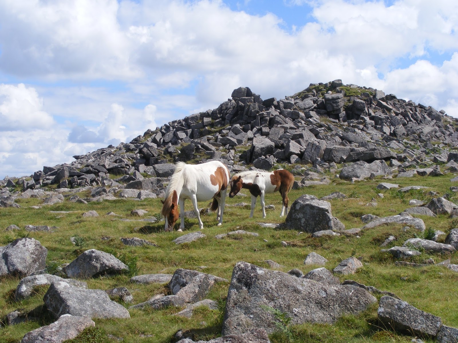
There were lots of Dartmoor ponies grazing on the slopes and they had young foals with them.


We walked along the ridge to Sharpitor, which has a lot more granite scree on its slopes.  We scrambled across the stones to reach its summit and have a different view of Burrator.


We decided to walk down from Sharpitor to the car park at its foot, but this was not such a good path as the one we had come up.  It was not such a clearly defined path and there were lots of stones along the way and at times it was very wet with streams and pools to be avoided.  But again it was a very gently slope and we soon came to the pool next to the car park, where more ponies had gathered.


We then walked along parallel to road back to our car.

This had not been a long walk, taking less than an hour, but it was one of the most scenic walks I have done.  It was slightly misty on the afternoon we went and we could still see for miles, it must be even better on a completely clear day.  This is definitely a walk I would recommend to others and I will be doing it again I am sure.

Friday, 19 July 2013

Longtimber Wood, Ivybridge

With the temperatures still in the high twenties, we needed to find another woodland walk, where we would keep cool as we walked.  We have been out to the woods above Ivybridge several times and thought it would make an ideal walk in the shade.

We parked the car under the railway viaduct and walked straight into the woods.  The path took us down to the edge of the River Erme and we walked along this for about half an hour.  The path was good until the last section and it was lovely walking by the fast running river.  There were lots of small waterfalls as the river rushed over large boulders.


Wednesday, 17 July 2013

Antony

As Antony has the National Collection of Day Lilies we thought we would go to see what they were looking like.  We were welcomed by the sight of some of these flowers just inside the entrance.


First we went into the summer garden, that was looking very colourful, although the colours of the plants seemed to be more muted than I remember from previous years.


The collection of day lilies were slightly past their best, no doubt because of the hot sunshine we have had lately, but they still gave a good display.


From the formal gardens of Antony House we walked through the grounds to Antony Woodland Garden.  It was pleasant to walk along the paths through shrubs, but there was not much woodland to give shade.  There was not any flowers out, except one flowering tree that was very beautiful.


Tuesday, 16 July 2013

Woodland walks

With temperatures in the mid 20s it was too hot to walk far in open countryside.  It was not even cool right on the coast.  Therefore we looked for walks in woodland so we would not get overheated.

On Sunday morning we decided to do a walk we have done before, parking the car at Bedford Bridge and walking along the river to Grenofen.  To begin with we followed the path by the side of the river Walkham, but it became very rough so we headed up to a higher path.  At times we could not see the river, but other times it came down close to the waters edge.  On the way back we went on an even higher path which was a very good track for walking though not so pleasant as you could not hear the river gurgling past.

River Walkham

On Monday we thought we would walk in Plymbridge Woods.  Usually we park at Plym Bridge and walk up the river Plym from there.  For a change we decided to park at Woolwell and explore the woodland around there that leads on to Plym Bridge Woods.

We parked in Pinewood Drive as we thought we would be able to get onto a path from there but we had to walk back past the bottom of several closes before we could enter the woods.  To begin with the path was narrow and a bit overgrown and after a while we had to go down a steep incline,but this led to a good path that took us all the way down to a viaduct over the river plym.  We then walked along the river until Bickleigh.  This is where the river path ends and we had to climb up a steep hill to reach the cycle path.  We followed the cycle path back until the second viaduct.  We had to scramble down a steep path to return to the path we needed to be on to return to Woolwell.

To avoid climbing up the steep path near the end of the walk we took another path back that looked as if it would get us back to our car.  Unfortunately it went past where we were parked and the Woolwell estate is designed in such a way that you can't get from one close to another but have to go back to the through roads.  We therefore had a longer walk back than we had anticipated.

The map route is saved on getamap.co.uk


Wednesday, 10 July 2013

Around Burrator

We have frequently visited Burrator Reservoir and walked around part of it using the quiet road that winds around it.  However, today was hot and sunny so we wanted a shaded walk so decided to try walking around the reservoir in the woodland that surrounds it.  We parked at the dam and immediately saw we were in for a very pretty walk as the water was sparkling and very blue.


We started walking towards Burrator House.  When we reached that gate that leads to the woodland path there was a sign saying the path was closed for repairs.  We continued walking on the road and soon came to a stile where we could enter the reservoir surrounds.  There was a definite path around the water, although there were no signs.  The path was generally good, although at times there were tree roots on the path and other times it was stony.  We were able to walk right down to the water edge and there were lovely views around the reservoir.


At one point we came upon a family of dartmoor ponies.


At various times as we walked we came upon patches of foxgloves that brightened the environment.


After walking along one bank of the reservoir we started walking along a river until we came to Norsworthy Bridge.  Here we had to climb over another stile to get onto the road.  Having crossed the bridge we had to walk along the road for a short while before going over another stile into the woodland again.  The path on this side of the reservoir was not so good and sometimes muddy.  At one  point we had to scramble down a small bank and cross a stream.

The walk took 2 hours in total and it was only in the last third that we came to seats.  There were several at the top end of the reservoir where there was a compacted path, and a lovely view.


The path came out to the road just before the dam so we did not have far to walk on the road before we were back at our car.  This is definitely a walk we will do again.

Sunday, 7 July 2013

Cann Wood

We have now lived in Plymouth for two and a half years.  During this time we have found many lovely places to walk, some close by and some further afield.  We often go to Plym Bridge and have seen a footpath up to Cann Woods but we have never explored this woods.  Today was a hot day and we only had a morning free to walk so we thought this would be a good place to go as it is only just outside Plymouth.

We chose to follow the walk which the Forestry Commission have marked out with blue posts, which was 2.75 miles.  It did not take us all the way down to the River Plym, but as that was in a valley it meant we did not have a steep climb up.  The walked was well marked which was as well as there were lots of paths criss-crossing the woods.  Whenever we came to a junction there was a post and then one a little way inside the correct path to reassure us we were on the right way.

There were lovely views at various parts of the walk, across the Plym valley to Estover, out to the moors, to the china clay workings etc. There were not many flowers to be seen except for foxgloves.
Foxgloves among new trees planted, with view of Dartmoor

Unfortunately the walk was not in as much in shade as we had hoped.  Some of the paths were amongst trees but most were in the open.  Normally this would not be a problem but today we would have appreciated a cooler walk.

This is definitely somewhere we will return to, next time we must follow the path to Plymbridge Woods and there is also the hill fort to view.